


Pont Cysyllte, Cysyllte and Cefn Mawr
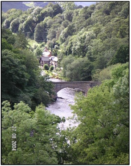 The Pont Cysyllte (bridge) and the old corn mill as seen from the Pontcysyllte Aqueduct
Cysyllte, is the name of a strip of land which juts out into the river Dee and research has revealed earlier forms for Cysyllte as Cysylle. This could indicate a description in past dialect of the remarkable banks and striking views in the area.
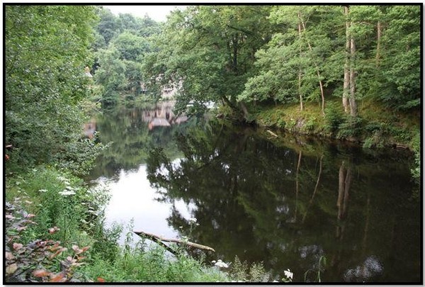 Cysyllte where the river moves slowly by, a real beauty spot in the Pontcysyllte World Heritage Site
The area was called Cysyllte and the Welsh word for bridge is Pont. Now in English this would be said as Cysyllte Bridge, but in the Welsh language this is said as Pont Cysyllte, or bridge Cysyllte and hence the bridge is called Pont Cysyllte. Furthermore the change from Cysylle to Cysyllte has been influenced by the many changes and transport links in the area.
There was once a ferry at Cysylle that crossed the River Dee in the fourteenth century. The most likely point for this lies just upstream of Pont Cysyllte, where the river meanders slowly due to the relative depth and width of the river at this point, making it ideal for a ferry crossing, unlike the fast and changing flow up and down stream of this point.
The next known ferry crossings was downstream at Erbistock where the same river conditions occur. At Erbistock the winch and steps for the ferry can still be seen at the Boat Inn. Upstream from Cysyllte the next early crossing of the River Dee takes place at Llangollen where a bridge has been in existence since at least the 13th century built by the Bishop, John Trevor. The present bridge is estimated to date back to 1500, with major repairs in 1656 and an additional span being added in 1863 to accommodate the age of steam and coming of the railway.
The ferry crossing at Cysyllte may well have once been in a Coracle type craft. Welsh coracles were oval in shape and very similar to half a walnut shell, the structure made from a framework of split and interwoven willow rods are tied with willow bark. The outer layer was animal skin such as horse or bullocks hide with a thin layer of tar to make it fully water proof. The craft are keel-less and flat bottom to evenly spread the weight of the boat and load reducing the draft and the subsequently required depth of water – often to only a few inches, making it ideal for use on rivers.
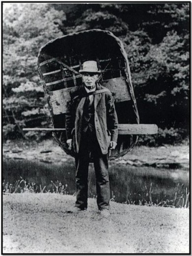
They are also an effective fishing vessel because, when powered by a skilled person, they hardly disturb the water or the fish, and can easily be maneuvered with one arm, while the other arm tends a net.
Another important aspect to the Welsh Coracle is that it can be carried on the back by one person.
Built for use in the streams and rivers of Wales and other parts of Britain and Ireland, the coracle has seen use for centuries, having been noted by Julius Caesar in his invasion of Britain in the first century BC.
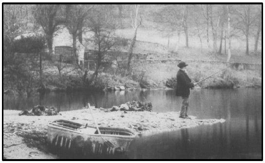 Fly fishing at the Salmon Pool, Cysyllte
Here we have a picture from of Richard Roberts fly fishing in 1890 at the “Salmon Pool” just upstream of Pont Cysyllte in 1890. The Roberts family lived in the locality for many generations and Richard was a friend of RF Graesser who often fished with him in his coracle.
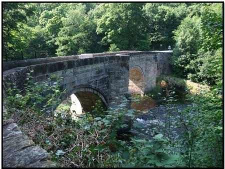
The Pont Cysyllte, stone bridge was builtin the 1690s on solid bed rock just downstream of where the ferry once crossed. The bridge is constructed with tough and resilient sand stone that has withstood the test of time and erosion by the mighty River Dee.
The freestone mother quarries fromwhere the sandstone was hewn were once out crops to be found to the north of the bridge in the high ridge of the hill from which Cefn Mawr gets its name.
The bridge was later substantially rebuilt in the 18th century, again with stone from the same quarries. This then helped support, and convey the supply stone for the much larger construction of the Pontcysyllte Aqueduct from 1795 to 1805.
 Pontcysyllte Aqueduct seen from the Pont Cysyllte (bridge)
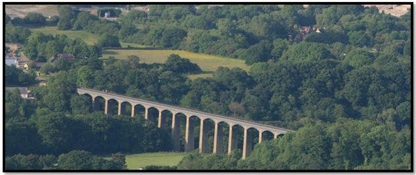 Pontcysyllte Aqueduct seen from the hill of Froncysyllte
Froncysyllte takes its name as the hill that overlooks Cysyllte, i.e. the hill overlooking the strip of land jutting into the river Dee. The elements in the place name are Fron (hill) and Cysyllte.
Cefn Mawr and surrounding villages of the Cefn, Froncysyllte, Trevor, Rhosymedre, Acrefair were largely borne out of the early industrial revolution with the construction of the Pontcysyllte Aqueduct and arrival of the canal. Until the arrival of the canal and the construction of the Pontcysyllte Aqueduct, the local population was small, mainly supported by farming and crofting, small scale quarrying and limited iron working.
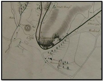 Cefn Common in 1795 and the genisis of Cefn Mawr today
With the construction of the Pontcysyllte Aqueduct and arrival of the canal there was a great increase in the local population and the poorer agricultural land, i.e. the hilly rocky slopes of the Cefn Mawr ridge where set aside as common ground to accommodate the increased work force. The Cefn Common is clearly marked on the map for the canal dated 1795. The Cefn Common was surrounded by the Plas Kynaston Estate which retained occupation of the more fertile and arable land and fields.
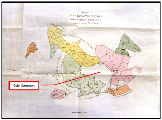 Plas Kynaston Estate & Cefn Common to the north west of Cysyllte
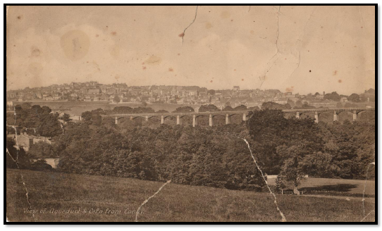 The Pontcysyllte Aqueduct and Cefn Mawr in 1900’s before Monsanto looking across Cysyllte
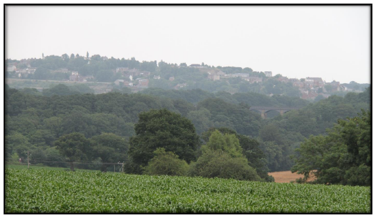 Cefn Mawr and the Pontcysyllte Aqueduct after Monsanto 2013, looking across Cysyllte.
Printable version of this webpage, courtesy of the PKC Group
Pont Cysyllte, Cysyllte Cefn Mawr, Cefn[...]
Adobe Acrobat document [1.9 MB]